Select Page

The impact of upzoing on housing construction in Auckland

Ryan Greenaway-McGrevy a, Peter C.B. Phillips a b c d

a The University of Auckland
b. Yale University, United States
c. Singapore Management University, Singapre
d. University of Soputhhampton, United Kingdom

  1. Home
  2.  • 
  3. Project
  4.  • The impact of upzoing on housing construction in Auckland

Introduction

Housing has become prohibitively expensive in many of the world’s major cities, precipitating serious and widespread housing affordability crises (Wetzstein, 2017). A growing coalition of researchers argue that part of the solution is to “upzone” cities by relaxing land use regulations (LURs) to allow construction of more intensive housing, such as townhouses, terrace housing and apartment buildings (Glaeser, Gyourko, 2003, Freeman, Schuetz, 2017, Manville, Monkkonen, Lens, 2019). Policymakers have begun to listen to these supply-side solutions and, in response, several metropolitan and gubernatorial authorities have pursued zoning reform in recent years (National Public Radio, 2019).

There is a growing debate about whether upzoning is an effective policy response to housing shortages and unaffordable housing. This paper provides empirical evidence to further inform debate by examining the various impacts of recently implemented zoning reforms on housing construction in Auckland, the largest metropolitan area in New Zealand. In 2016, the city upzoned approximately three quarters of its residential land to facilitate construction of more intensive housing. We use a quasi-experimental approach to analyze the short-run impacts of the reform on construction, allowing for potential shifts in construction from non-upzoned to upzoned areas (displacement effects) that would, if unaccounted for, lead to an overestimation of treatment effects. We find strong evidence that upzoning stimulated construction. Treatment effects remain statistically significant even under implausibly large displacement effects that would necessitate more than a four-fold increase in the trend rate of construction in control areas under the counterfactual of no-upzoning. Our findings support the argument that upzoning can stimulate housing supply and suggest that further work to identify factors that mediate the efficacy of upzoning in achieving wider objectives of the policy would assist policymakers in the design of zoning reforms in the future.

Institutional background

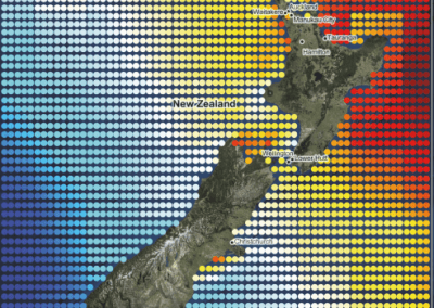
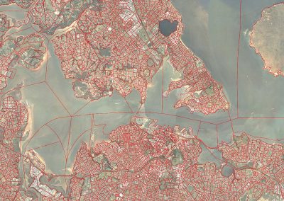
Auckland with a population of approximately 1.57 million within the greater metropolitan region (as of the 2018 census). Prior to 2010, the metropolitan region comprised seven different city and district councils. Since 2010, the entire metropolitan area, as well as several towns, populated islands, and a large amount of the rural land beyond the fringes of its outermost suburbs, has been under the jurisdiction of a single local government, the Auckland Council. Centered on a long isthmus of land between two harbors, this jurisdiction extends over 4894 km 2 of land area. Figure 1 illustrates the Auckland region, decomposed into Statistical Areas (SAs), which, as discussed below, are used as the geographic unit of analysis in our work. The shaded areas are the Auckland Council region. The lighter shaded area in the center is what we refer to as the “urban core”. 1 In March 2013, the Auckland Council announced the “draft” version of the Auckland Unitary Plan (AUP). The draft version of the plan went through several rounds of consultations, reviews and revisions before the final version became operational on 15 November 2016.

In this study we focus on four residential zones introduced under the AUP, listed in declining levels of permissible site development: Terrace Housing and Apartments (THA); Mixed Housing Urban (MHU); Mixed Housing Suburban (MHS); and Single House (SH). Thus THA allows the most site development, and SH allows the least. Table 1 summarizes the various LURs for each of the four residential zones considered. These regulations include site coverage ratios, height restrictions, setbacks and building envelopes, among others.2

Annotate:

1. For the urban core, we use statistical areas inside or overlapping the “Major Urban Area ”of the greater metropoitan region, as defined by Statistics New Zealand.
2 There are two additional zones in the AUP that are classified as “Residential”: “Large Lot ”and “Rural and Coastal Settlement ”. We exclude these areas from our analysis as they are an intermediate, semi-rural zone between outright rural and urban housing areas. We also omit residential land on the islands in the Hauraki Gulf, which have their own unique zoning under the AUP.

Figure 1. Auckland region.
Notes: Auckland region (shaded) decomposed into Statistical Area geographic units. Urban core shaded yellow in the center. (For interpretation of the references to color in this figure legend, the reader is referred to the web version of this article.)

Table 1. Summary of land use regulations by residential zone under the Auckland unitary plan.
Notes: Tabulated restrictions are “as of right ”and can be exceeded through resource consent notification. Number of storeys (in parentheses) are obtained from the stated purpose of the height restriction in the regulations. Height in relation to boundary and setbacks apply to side and rear boundaries. Less restrictive height in relation to boundary rules than those tabulated apply to side and rear boundaries within 20m of site frontage. Maximum dwellings per site are the number allowed as of right. Minimum lot sizes per dwelling do not apply to existing residential parcels. Site coverage is the area under the dwelling structure. Impervious area is the area under the dwelling and structures such as concrete driveways that prevent rainwater absorption into soil.
Our empirical design uses the introduction of the AUP as a quasi-natural experiment in which residential areas that were upzoned to either MHS, MHU or THA are designated as treatment areas, while residential areas that were not upzoned (including SH) are control areas. In order to identify upzoned areas, we compare the LURs that applied before and after the AUP. Prior to the AUP, each of the seven city and district councils set their own zoning regulations, which remained in effect until the AUP became operational in 2016. Upzoned areas are identified by comparing the maximum floor area ratios (FARs) under the previous zone to those that applied under the zone introduced under the AUP. Areas where the FAR increased are classified as upzoned. Although neither the AUP nor the seven city and district plans placed direct restrictions on FARs, all sets of plans imposed site coverage ratios and height limits that cap the maximum allowable FAR on a parcel. Under a plausible mapping of building height to storeys, the FAR is straightforwardly the product of the storey limit and the site coverage ratio. Further details on the classification method are given in the Appendix.3 Using this approach, approximately three-quarters (75.2%) of all residential land (SH, MHS, MHU and THA zones combined) is classified as upzoned, including the vast majority (98.7%) of the land designated as either THA, MHU or MHS.4 Meanwhile, 96.2% of residential land had a FAR no greater than that of SH under the AUP. Thus, while the previous set of regulations did allow for housing intensity that was roughly equivalent to MHS, MHU or THA, these zones were restricted to very small, targeted areas. Our sample period spans several demand-side policies intended to curb housing demand to promote affordability, including severe restrictions on foreign ownership, disincentives to investor speculation, and macroprudential banking restrictions.5 Although these policies frequently exempted new builds, there is little reason to think that these policies would differentially impact upzoned areas. Moreover, as we illustrate below, the parallel trends assumption holds remarkably well in our data, affirming that these policies did not have a differential impact. On the supply side, prior to the AUP, “Special Housing Areas ”(SpHA) incentivized developers to provide a limited amount of affordable housing in exchange for accelerated processing of building permits. Developers could also use more relaxed planning rules from a preliminary version of the plan (the “Proposed AUP ”, notified in September 2013). SpHAs were disestablished once the AUP became operational. We exclude permits issued in SpHAs prior to 2017 as a disproportionate share of SpHA permits are in locations that were later upzoned. A robustness check reported in the Appendix demonstrates that our findings are largely unaffected when these permits are included in the analysis.

Dataset

Our dataset is based on annual building permits for new dwelling units issued by the Auckland Council from 2010 to 2021.6 The permits include the number of dwellings. Each observation includes the longitude and latitude of the building site, which have been used to map each permit to its corresponding zone under the Auckland Unitary Plan (AUP).
Figure 2 exhibits aggregate permits in upzoned and non-upzoned residential areas over the 2010 to 2021 period. We also decompose permits into attached and detached dwellings. There is a clear increase in the number of permits in upzoned areas after the policy is implemented (from 2017 onward). The number of attached dwelling permits per year in upzoned areas increases from under 1000 in 2016 to near 10,000 by 2021 –more than a tenfold increase. Over the same period, detached housing increases from just over 2000 permits per year to approximately 4500. By 2019, there were more attached dwelling permits than detached, consistent with the upzoning goal of incentivising more capital intensive structures. In addition, there is a notable fall in detached dwelling permits between 2019 and 2021 in upzoned areas.

Prior to the policy change, permits in subsequently upzoned areas consistently exceeded permits in non-upzoned areas by a relatively constant amount. This pattern is consistent with modeling permits in levels in a difference-in-differences framework, since it implies an absolute difference in the level of the two series under the counterfactual (Kahn-Lang and Lang, 2020 ).
Economic theories of urban development suggest that upzoning will encourage construction in desirable locations where zoning regulation was previously binding, such as areas close to job locations. The canonical Alonso-Muth-Mills (AMM) spatial equilibrium model of the mono- centric city predicts that a relaxation of Land Use Regulations (LURs) will result in more housing close to the city to the center ( Bertaud and Brueckner, 2005 ). To explore whether this is the case in Auckland, Figure 3 (a.b.) divides the sample into urban core and non-core areas of Auckland (see Figure 1 for the geographic delineation of the urban core and non-core areas). Consistent with this prediction, most of the increase in permits in upzoned areas is occurring in the urban core. Figure 4 breaks down the upzoned areas into constituent Terrace Housing and Apartments (THA), Mixed Housing Urban, (MHU) and Mixed Housing Suburban (MHS) zones. Despite having more restrictive constraints than MHU and THA, it is unsurprising that MHS accounts for most of the increase in permits because it covers the largest geographic area.

Figure 2. Dwelling permits, 2010–2021. Notes: Dwelling permits issued in up- zoned and non-upzoned residential areas.
Figure 3a and 3b. Dwelling permits inside and outside the urban core, 2010–2021. Notes: Urban core depicted in Figure 1 .

Empirical model and result

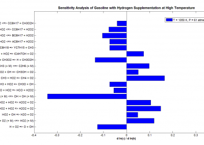
Figure 5 shows OLS estimates of the coefficients alongside 95% confidence intervals (standard errors are clustered by SA). Recall that we set the treatment to occur in 2015. The top panel of the Figure displays results for all dwellings, while the middle and bottom panels display results for detached and attached dwellings, respectively. Evidently there is no apparent trend in the estimated coefficients prior to treatment in any of the three samples, so the parallel trends assumption appears to hold. Further buttressing the DID framework, we find no evidence of anticipation in land prices or sales volumes prior to policy announcement, nor selection into treatment based on specifications that admit neighborhood-specific trends. The response to the zoning change is immediate: The estimated treatment effects increase every year after implementation. By 2021, five years after the policy was introduced, some 23.06 additional permits are issued, on average, in upzoned areas compared to non-upzoned areas in each of the 479 SAs. This would correspond to 11,044 permits across the city. Cumulating the corresponding figures for 2016 through 2021 yields 34,614 additional permits in upzoned areas compared to non-upzoned areas. Treatment effects for attached dwellings exceed detached from 2019 onwards. By 2021, the estimated treatment effect for attached is 17.96 permits, while for detached it is 5.09. The original paper was published in Journal of Urvan Economics, For detailed analysis and model equations, please refer to the original paper https://doi.org/10.1016/j.jue.2023.103555.

 
Figure 4. Dwelling permits by residential zone, 2010–2021. Notes: Dwelling permits issued in non-upzoned and upzoned residential areas.

Discussion

The empirical findings show strong evidence to support the conclusion that upzoning raised dwelling construction in the city of Auckland. Set-identified treatment effects remain statistically significant even under counterfactual sets that include an implausibly large, four-fold increase in the trend rate of construction in control areas under the counterfactual of no-upzoning. The data also reveal that much of this increase is in the form of the more capital intensive, attached (or multifamily) structures in the inner suburbs of the city. These findings are a positive sign for proponents of upzoning as a solution to unresponsive housing supply, particularly when compared to recent studies that show that zoning reforms have not had a substantial impact on housing construction ( Freemark, 2019; Limb and Murray, 2022 ). Although the present paper does not explicitly identify factors that mediate the efficacy of zoning reforms in different contexts, comparisons to other reforms may shed light on the underlying mechanisms and thereby assist in directing future research. For example, the large-scale upzoning in Auckland may have fostered greater competition in land supply to developers, resulting in lower upzoned land prices than would have occurred if the policy had instead been restricted to specific neighborhoods or transit corridors. Alternatively, demand for housing in Auckland has significantly outstripped supply over the past few decades, resulting in housing that is amongst the most expensive in the world when measured against local incomes: Auckland may have significantly more latent demand for housing than other cities. We anticipate future research will address these questions to further guide policymakers in the design and implementation of zoning reforms. We conclude by noting that the impact of upzoning on housing construction and housing markets will continue to be felt over coming years. Permits for attached dwellings are still trending upwards and permits for detached dwellings remain significantly above their pre-upzoning average. In future work, and as new data become available, the impact of the policy on the housing stock will be updated and new research will seek to determine the particular characteristics of parcels that predict the uptake of redevelopment. Such findings should be useful in assisting the design and refinement of future upzoning policies.

Figure 5. Estimated treatment effects, 2010–2021. Notes: Estimated treatment effects (circles) and 95% confidence intervals (error bars). Treatment date is 2015. Outcome is permits per statistical area.

 Annotate:

3. FARs are often used as a measure of LUR stringency; see Brueckner et al. (2017) ; Brueckner and Singh (2020) and Tan et al. (2020) . By using a FAR, our upzoning identification algorithm is based on increases in maximum floorspace density, rather than restrictions on dwelling density, such as minimum lot sizes (MLS). While the majority of the zones prior to the AUP also had MLS in addition to height and site coverage restrictions, MLS do not apply to extant residential parcels under the AUP. MLS on extant parcels were therefore an additional restriction that only applied prior to the AUP, which means that our upzoning classification method may understate the amount of upzoned land.
4 We also consider empirical designs in which THA, MHU and MHS are simply classified as the treatment group and SH areas are the control group, and where downzoned areas are excluded from the analysis. Our results and findings do not substantively change.
5. Loan to value ratios on new residential mortgages were introduced in 2013; a limited capital gains tax was introduced in 2015; and legislation preventing foreign ownership (excepting Australia and Singapore) in 2018. See Greenaway- McGrevy and Phillips (2021) for additional details.
6.Permits for extensions to existing dwellings are not included in our analysis.


Reference

  1. Bertaud, A., Brueckner, J.K., 2005. Analyzing building-height restrictions: predicted impacts and welfare costs. Reg. Sci. Urban Econ. 35 (2), 109–125. doi:10.1016/j.regsciurbeco.2004.02.004 .
  2. Brueckner, J.K., Fu, S., Gu, Y., Zhang, J., 2017. Measuring the stringency of land use regulation: the case of China’s building height limits. Rev. Econ. Stat. 99 (4), 663–677. doi:10.1162/REST_a_00650 .
  3. Brueckner, J.K., Singh, R., 2020. Stringency of land-use regulation: building heights in US cities. J. Urban Econ. 116 (January), 103239. doi:10.1016/j.jue.2020.103239 .
  4. Freeman, L., Schuetz, J., 2017. Producing affordable housing in rising markets: What works? Cityscape 19, 217–236.
  5. Freemark, Y., 2019. Upzoning chicago: impacts of a zoning reform on property
    values and housing construction:. Urban Aff. Rev. 56 (3), 758–789.doi:10.1177/1078087418824672.
  6. Kahn-Lang, A., Lang, K., 2020. The promise and pitfalls of differences-in-differences: reflections on 16 and pregnant and other applications. J. Bus. Econ. Stat. 38 (3), 613–620. doi: 10.1080/07350015.2018.1546591.
  7. Glaeser, E., Gyourko, J., 2003. The impact of building restrictions on housing affordability. Econ. Policy Rev. 9 (2), 21–39 .
  8. Greenaway-McGrevy, R., Phillips, P.C.B., 2021. House prices and affordability. New Zealand Econ. Pap. 55 (1), 1–6. doi:10.1080/00779954.2021.1878328.
  9. Limb, M., Murray, C.K., 2022. We zoned for density and got higher house
    prices: supply and price effects of upzoning over 20 years. Urban Policy Res.doi:10.1080/08111146.2022.2124966. https://www.osf.io/zkt7v/.
  10. Manville, M., Monkkonen, P., Lens, M., 2019. It’s time to end single-family zoning. J. Am. Plan. Assoc. 86 (1), 106–112. doi: 10.1080/01944363.2019.1651216.
  11. National Public Radio, 2019. Across America: How U.S. Cities Are Tackling The Affordable Housing Crisis. https://www.npr.org/2019/08/28/755113175/1a-across-america-how-u-s-cities-are-tackling-the-affordable-housing-crisis .
  12. Tan, Y., Wang, Z., Zhang, Q., 2020. Land-use regulation and the intensive
    margin of housing supply. J. Urban Econ. 115 (October 2019), 103199.
    doi:10.1016/j.jue.2019.103199 .
  13. Wetzstein, S., 2017. The global urban housing affordability crisis. Urban Stud. 54 (14),3159–3177. doi:10.1177/0042098017711649.


See more case study projects

The impact of upzoing on housing construction in Auckland

The impact of upzoing on housing construction in Auckland

Extended reality is turning cancer research into a team sport

Extended reality is turning cancer research into a team sport

Analysis of incidents on New Zealand beaches

Analysis of incidents on New Zealand beaches

Painting the brain: multiplexed tissue labelling of human brain tissue to facilitate discoveries in neuroanatomy

Painting the brain: multiplexed tissue labelling of human brain tissue to facilitate discoveries in neuroanatomy

Decoding the work-from-home phenomenon: insights from location-based service data

Decoding the work-from-home phenomenon: insights from location-based service data

The use of digital footprints in the US mortgage market

The use of digital footprints in the US mortgage market

Detecting anomalous matches in professional sports: a novel approach using advanced anomaly detection techniques

Detecting anomalous matches in professional sports: a novel approach using advanced anomaly detection techniques

Benefits of linking routine medical records to the GUiNZ longitudinal birth cohort: Childhood injury predictors

Benefits of linking routine medical records to the GUiNZ longitudinal birth cohort: Childhood injury predictors

Using a virtual machine-based machine learning algorithm to obtain comprehensive behavioural information in an in vivo Alzheimer’s disease model

Using a virtual machine-based machine learning algorithm to obtain comprehensive behavioural information in an in vivo Alzheimer’s disease model

Mapping livability: the “15-minute city” concept for car-dependent districts in Auckland, New Zealand

Mapping livability: the “15-minute city” concept for car-dependent districts in Auckland, New Zealand

Quantifying gas narcosis in compressed gas diving

Quantifying gas narcosis in compressed gas diving

Estimating quality of life: a spatial microsimulation model of wellbeing in Aotearoa New Zealand

Estimating quality of life: a spatial microsimulation model of wellbeing in Aotearoa New Zealand

Video compression for REACH Lab’s study of  family resilience and wellbeing

Video compression for REACH Lab’s study of family resilience and wellbeing

Listening to equations: a tool for the audification of heteroclinic networks

Listening to equations: a tool for the audification of heteroclinic networks

The Effects of Short-Term Tourist Rentals on Local Residents

The Effects of Short-Term Tourist Rentals on Local Residents

Accounting for Errors in Data Improves Divergence Time Estimates in Single-cell Cancer Evolution

Accounting for Errors in Data Improves Divergence Time Estimates in Single-cell Cancer Evolution

VRhook: A Data Collection Tool for VR Motion Sickness Research

VRhook: A Data Collection Tool for VR Motion Sickness Research

Ahuahu Great Mercury Island Online Database

Ahuahu Great Mercury Island Online Database

Automating Data Collection and Generation for The Rongowai Mission

Automating Data Collection and Generation for The Rongowai Mission

Travelling Heads – Measuring Reproducibility and Repeatability of Magnetic Resonance Imaging in Dementia

Travelling Heads – Measuring Reproducibility and Repeatability of Magnetic Resonance Imaging in Dementia

Novel Subject-Specific Method of Visualising Group Differences from Multiple DTI Metrics without Averaging

Novel Subject-Specific Method of Visualising Group Differences from Multiple DTI Metrics without Averaging

Interpretation of Non-coding Mutations Driving Melanoma Risk and Its Comorbidities

Interpretation of Non-coding Mutations Driving Melanoma Risk and Its Comorbidities

Who Are The 1M and 1X? Police Engagement with Citizens in Mental Distress

Who Are The 1M and 1X? Police Engagement with Citizens in Mental Distress

Representation of Multimodel Data – A Challenging Task

Representation of Multimodel Data – A Challenging Task

Assessing Marine Ecosystems to Improve Management

Assessing Marine Ecosystems to Improve Management

Metadata Catalogue in High Value  Nutrition (National Science Challenge)

Metadata Catalogue in High Value Nutrition (National Science Challenge)

Improving In Vitro Fertilisation (IVF) with Machine and Deep Learning

Improving In Vitro Fertilisation (IVF) with Machine and Deep Learning

Pacific Rheumatic Fever Project

Pacific Rheumatic Fever Project

Developing a genomics-specific Data Management Plan (DMP) using the  Data Stewardship Wizard

Developing a genomics-specific Data Management Plan (DMP) using the Data Stewardship Wizard

Understanding the effects of Airbnb on land use, land value and regulation

Understanding the effects of Airbnb on land use, land value and regulation

Calibrating gravitational wave signal parameters of Extreme Mass Ratio Inspirals (EMRIs)

Calibrating gravitational wave signal parameters of Extreme Mass Ratio Inspirals (EMRIs)

Automated stone artefacts classification using machine learning

Automated stone artefacts classification using machine learning

Hands-on DNA: exploring the impact of virtual reality on teaching DNA structure and function

Hands-on DNA: exploring the impact of virtual reality on teaching DNA structure and function

Re-assess urban spaces under COVID-19 impact: sensing Auckland social ‘hotspots’ with mobile location data

Re-assess urban spaces under COVID-19 impact: sensing Auckland social ‘hotspots’ with mobile location data

Aotearoa New Zealand’s changing coastline – Resilience to Nature’s Challenges (National Science Challenge)

Aotearoa New Zealand’s changing coastline – Resilience to Nature’s Challenges (National Science Challenge)

Auckland housing and land use geo-data

Auckland housing and land use geo-data

Rapid monitoring of infrastructural health using remote sensing

Rapid monitoring of infrastructural health using remote sensing

Enhancing Spontaneous Recovery after Stroke Study (ESPRESSo)

Enhancing Spontaneous Recovery after Stroke Study (ESPRESSo)

Data analytics and visualisation for improving  public health and transport planning

Data analytics and visualisation for improving public health and transport planning

Data maturity project in High Value Nutrition (Phase 2) – National Science Challenge

Data maturity project in High Value Nutrition (Phase 2) – National Science Challenge

Supporting the airborne remote sensing mission – Rongowai

Supporting the airborne remote sensing mission – Rongowai

A collaborative extended reality tool to examine tumour evolution (Phase II)

A collaborative extended reality tool to examine tumour evolution (Phase II)

Data maturity project in High Value Nutrition, National Science Challenge

Data maturity project in High Value Nutrition, National Science Challenge

Haka on the move: sport circuits and cultural performance 

Haka on the move: sport circuits and cultural performance 

Proteins under a computational microscope: designing in-silico strategies to understand and develop molecular functionalities in Life Sciences and Engineering

Proteins under a computational microscope: designing in-silico strategies to understand and develop molecular functionalities in Life Sciences and Engineering

Remote temperature monitoring to reduce the spread of COVID-19

Remote temperature monitoring to reduce the spread of COVID-19

COVID-19 exponential growth visualisation

COVID-19 exponential growth visualisation

Developing virtual capabilities for the Science Payload Operations Centre

Developing virtual capabilities for the Science Payload Operations Centre

Hosting visualisation and analytics tools for COVID-19 studies

Hosting visualisation and analytics tools for COVID-19 studies

Exploring perceptions towards climate change over time on Twitter

Exploring perceptions towards climate change over time on Twitter

Coastal image classification and nalysis based on convolutional neural betworks and pattern recognition

Coastal image classification and nalysis based on convolutional neural betworks and pattern recognition

Calcium signalling in salivary gland acinar cells

Calcium signalling in salivary gland acinar cells

Anti-corruption regulations for promoting socially responsible practices

Anti-corruption regulations for promoting socially responsible practices

Determinants of translation efficiency in the evolutionarily-divergent protist Trichomonas vaginalis

Determinants of translation efficiency in the evolutionarily-divergent protist Trichomonas vaginalis

Analysing text data by time-series feature engineering

Analysing text data by time-series feature engineering

An investigation into Leap Motion device for “gesture-as-sign”

An investigation into Leap Motion device for “gesture-as-sign”

Antibiotic resistance and the “end of modern medicine ”

Antibiotic resistance and the “end of modern medicine ”

Develop short-term eruption warning systems for Whakaari and other volcanoes

Develop short-term eruption warning systems for Whakaari and other volcanoes

Evenly spaced observation fields from irregularly sampled data in the Southern Ocean

Evenly spaced observation fields from irregularly sampled data in the Southern Ocean

Measuring impact of entrepreneurship activities on students’ mindset, capabilities and entrepreneurial intentions

Measuring impact of entrepreneurship activities on students’ mindset, capabilities and entrepreneurial intentions

Using Zebra Finch data and deep learning classification to identify individual bird calls from audio recordings

Using Zebra Finch data and deep learning classification to identify individual bird calls from audio recordings

NETwork! analysis in cancer – managing genomics research data and building a repository workflow

NETwork! analysis in cancer – managing genomics research data and building a repository workflow

The Coronary Atlas – data processing workflow optimisation

The Coronary Atlas – data processing workflow optimisation

3D visualisation of indigenous burial site in Roonka

3D visualisation of indigenous burial site in Roonka

Automated measurement of intracranial cerebrospinal fluid volume and outcome after endovascular thrombectomy for ischemic stroke

Automated measurement of intracranial cerebrospinal fluid volume and outcome after endovascular thrombectomy for ischemic stroke

A new ‘stratigraphy’: interpreting object relationships with 3D point densities

A new ‘stratigraphy’: interpreting object relationships with 3D point densities

Towards the use of deep learning techniques for storm surge prediction

Towards the use of deep learning techniques for storm surge prediction

Using simple models to explore complex dynamics: A case study of macomona liliana (wedge-shell) and nutrient variations

Using simple models to explore complex dynamics: A case study of macomona liliana (wedge-shell) and nutrient variations

Development of Machine Learning methodology for genomic research

Development of Machine Learning methodology for genomic research

An Archaeological database for threatened North Island rock art in New Zealand

An Archaeological database for threatened North Island rock art in New Zealand

Presence: distributed mixed reality learning environment

Presence: distributed mixed reality learning environment

Digital video and the early learning lab

Digital video and the early learning lab

Publishing the Bay of Island Bottlenose dolphin catalogue

Publishing the Bay of Island Bottlenose dolphin catalogue

Modelling the diurnal cycle* of winds and clouds

Modelling the diurnal cycle* of winds and clouds

Presence: distributed mixed reality learning environment

Presence: distributed mixed reality learning environment

Using research virtual machines to analyse fMRI datasets

Using research virtual machines to analyse fMRI datasets

Genomic Virtual Lab (GVL) as a bioinformatics training platform

Genomic Virtual Lab (GVL) as a bioinformatics training platform

SwiftLaTeX- Exploring web-based true WYSIWYG editing for digital publishing

SwiftLaTeX- Exploring web-based true WYSIWYG editing for digital publishing

Climate change impacts on weather-related hazards

Climate change impacts on weather-related hazards

Understanding tumour evolution through augmented reality

Understanding tumour evolution through augmented reality

Myocardial motion tracking and strain calculation using Deep Learning networks

Myocardial motion tracking and strain calculation using Deep Learning networks

OnTask pilot at the Centre for Learning and Research in Higher Education

OnTask pilot at the Centre for Learning and Research in Higher Education

Visualising the University campus in 3D

Visualising the University campus in 3D

Visualising protein interaction

Visualising protein interaction

Biological heritage National Science Challenge eDNA virtual hub

Biological heritage National Science Challenge eDNA virtual hub

Interactive AR art – Project Gordon

Interactive AR art – Project Gordon

1-D numerical models of post-glacial river evolution

1-D numerical models of post-glacial river evolution

Mathematically modelling gastrointestinal electrical activity

Mathematically modelling gastrointestinal electrical activity

3D Cryo-EM reconstructions of macromolecular complexes

3D Cryo-EM reconstructions of macromolecular complexes

Engine knock in a spark-ignition engine with hydrogen supplementation

Engine knock in a spark-ignition engine with hydrogen supplementation

The complex unsteady flow within a fluid-filled annulus and its transition to turbulence

The complex unsteady flow within a fluid-filled annulus and its transition to turbulence

Using data mining for digital ink recognition

Using data mining for digital ink recognition

The landscape costs of brushtail possum dispersal

The landscape costs of brushtail possum dispersal

Accelerating the discovery of natural products made by orphan megasynthases

Accelerating the discovery of natural products made by orphan megasynthases

Improving the short term precipitation forecasts for New Zealand

Improving the short term precipitation forecasts for New Zealand

Finding genetic variants responsible  for human disease hiding in the universe of benign variants

Finding genetic variants responsible for human disease hiding in the universe of benign variants

Revealing key processes in enzyme efficiency through high performance computing

Revealing key processes in enzyme efficiency through high performance computing

3D Electromagnetic modeling and simulation using heterogeneous computing

3D Electromagnetic modeling and simulation using heterogeneous computing

Hemodynamics in the microcirculation

Hemodynamics in the microcirculation

Putting turbulence to work

Putting turbulence to work

Why are some molecules drugs?

Why are some molecules drugs?

Bayesian additive regression trees  vs logistic regression – estimation of propensity scores

Bayesian additive regression trees vs logistic regression – estimation of propensity scores

Fully coupled thermo-hydro-mechanical modelling of permeability enhancement by the finite element method

Fully coupled thermo-hydro-mechanical modelling of permeability enhancement by the finite element method

Modelling dispersal and ecological competition in a statistical phylogeographic framework

Modelling dispersal and ecological competition in a statistical phylogeographic framework

Studying the shape and the size of the universe

Studying the shape and the size of the universe

Planet hunting

Planet hunting

Simulating quantum mechanics on high performance computing cluster

Simulating quantum mechanics on high performance computing cluster

Multiscale modelling of saliva secretion

Multiscale modelling of saliva secretion

Modelling dual reflux pressure swing adsorption (DR-PSA) units for gas separation in natural gas processing

Modelling dual reflux pressure swing adsorption (DR-PSA) units for gas separation in natural gas processing

Improving the treatment of heart disease

Improving the treatment of heart disease

Estimating migration rates in the budding yeast Saccharomyces cerevisiae

Estimating migration rates in the budding yeast Saccharomyces cerevisiae

Number theoretic algorithms in cryptography

Number theoretic algorithms in cryptography

Molecular phylogenetics uses genetic data to reconstruct the evolutionary history of individuals, populations or species

Molecular phylogenetics uses genetic data to reconstruct the evolutionary history of individuals, populations or species

Phylogeny and phylogeography of the family kyphosidae (Perciformes: teleostei)

Phylogeny and phylogeography of the family kyphosidae (Perciformes: teleostei)

Testing what cosmic inflation really predicts

Testing what cosmic inflation really predicts

Multigene environmental DNA data analysis for New Zealand genomic observatory

Multigene environmental DNA data analysis for New Zealand genomic observatory

Finding genetic variants responsible for human disease hiding in universe of benign variants

Finding genetic variants responsible for human disease hiding in universe of benign variants

BEAST, Bayesian evolutionary analysis sampling trees

BEAST, Bayesian evolutionary analysis sampling trees

The formation of surface archaeological deposits in arid Australia

The formation of surface archaeological deposits in arid Australia

Statistical modelling of carryover effects after cessation of treatments

Statistical modelling of carryover effects after cessation of treatments

High-resolution cryo-electron microscopy of protein complexes and machines

High-resolution cryo-electron microscopy of protein complexes and machines

ARCI, archaeology eResearch collaboration initiative

ARCI, archaeology eResearch collaboration initiative

Optimisation of blades on large wind turbines with individual pitch control and trailing edge flaps

Optimisation of blades on large wind turbines with individual pitch control and trailing edge flaps

Quality of care and outcomes in children with cleft lip and/or palate

Quality of care and outcomes in children with cleft lip and/or palate

Geographic and temporal information retrieval on massive document collections

Geographic and temporal information retrieval on massive document collections

Homodynamics in the microcirculation

Homodynamics in the microcirculation

Processing structure-from-motion photogrammetry on the cluster

Processing structure-from-motion photogrammetry on the cluster

Computational investigation of catalysis mechanisms for polyurethane synthesis

Computational investigation of catalysis mechanisms for polyurethane synthesis

Virtual childhood obesity prevention laboratory

Virtual childhood obesity prevention laboratory

Giving Pacific research greater reach

Giving Pacific research greater reach

Development of novel waveguides  in the terahertz (THz) region

Development of novel waveguides in the terahertz (THz) region

Modelling of costs of diets  by INFORMAS

Modelling of costs of diets by INFORMAS

Foodback

Foodback

Finite element method code for  modelling biological cells

Finite element method code for modelling biological cells

The future of memory: Neuroimaging memory and imagination with functional MRI

The future of memory: Neuroimaging memory and imagination with functional MRI

Modelling and visualisation of calcium waves in parotid acinar cells

Modelling and visualisation of calcium waves in parotid acinar cells

Mapping donor contributions in the Pacific

Mapping donor contributions in the Pacific

Visualising humpback whale migration

Visualising humpback whale migration

Visualising the 2010 and 2011  Canterbury earthquakes

Visualising the 2010 and 2011 Canterbury earthquakes

Data management planning for MOA*

Data management planning for MOA*

Research data publishing  and preservation at COMPASS

Research data publishing and preservation at COMPASS

Centre for eResearch machine learning service

Centre for eResearch machine learning service

Building a discrete global  grid gazetteer service

Building a discrete global grid gazetteer service

The new Wanhal catalogue

The new Wanhal catalogue

Passive acoustic modelling

Passive acoustic modelling

Using GPUs to expand our understanding of the Solar System

Using GPUs to expand our understanding of the Solar System

Shedding new light on dark matter

Shedding new light on dark matter

Aerodynamics modelling paves the way for improved yacht designs

Aerodynamics modelling paves the way for improved yacht designs

Modernising models to help diagnose or treat disease and injury

Modernising models to help diagnose or treat disease and injury

Wandering around the molecular landscape: embracing virtual reality as a research showcasing outreach and teaching tool

Wandering around the molecular landscape: embracing virtual reality as a research showcasing outreach and teaching tool

ALTER: Between human and nonhuman – a VR art exhibition

ALTER: Between human and nonhuman – a VR art exhibition

Disposition of Microsoft HoloLenses for a Pop-Up Reality Shop to demonstrate the progress of a research project

Disposition of Microsoft HoloLenses for a Pop-Up Reality Shop to demonstrate the progress of a research project

Improving diagnosis for schistosomiasis by using the ‘metabolic footprint’ of urine samples from an animal model of Schistosoma infection to identify possible biomarkers

Improving diagnosis for schistosomiasis by using the ‘metabolic footprint’ of urine samples from an animal model of Schistosoma infection to identify possible biomarkers

Making stroke recovery prediction tools freely available

Making stroke recovery prediction tools freely available

MFT-ICR mass spectrometry data management and analysis workflow

MFT-ICR mass spectrometry data management and analysis workflow

Taking a ‘Big Data’ approach to find new clinical-omic associations in cancer

Taking a ‘Big Data’ approach to find new clinical-omic associations in cancer

Growing Up in New Zealand

Growing Up in New Zealand

Improving arrival time predictions for vehicles in a public transport network

Improving arrival time predictions for vehicles in a public transport network

Distributed and cloud-based control at field-level for systems interacting with soft bodies

Distributed and cloud-based control at field-level for systems interacting with soft bodies

Mobile Click Fraud Attack (MCFA)

Mobile Click Fraud Attack (MCFA)

Skin-omics: exploring the volatile organic compounds on human skin

Skin-omics: exploring the volatile organic compounds on human skin

New analytics tools for workload planning for the 2018 New Zealand Census

New analytics tools for workload planning for the 2018 New Zealand Census

Visualising the New Zealand Index of Multiple Deprivation

Visualising the New Zealand Index of Multiple Deprivation